MIST Lab Explores the Data Landscape of NOVA: "In the Shadow of the Cloud"
Image

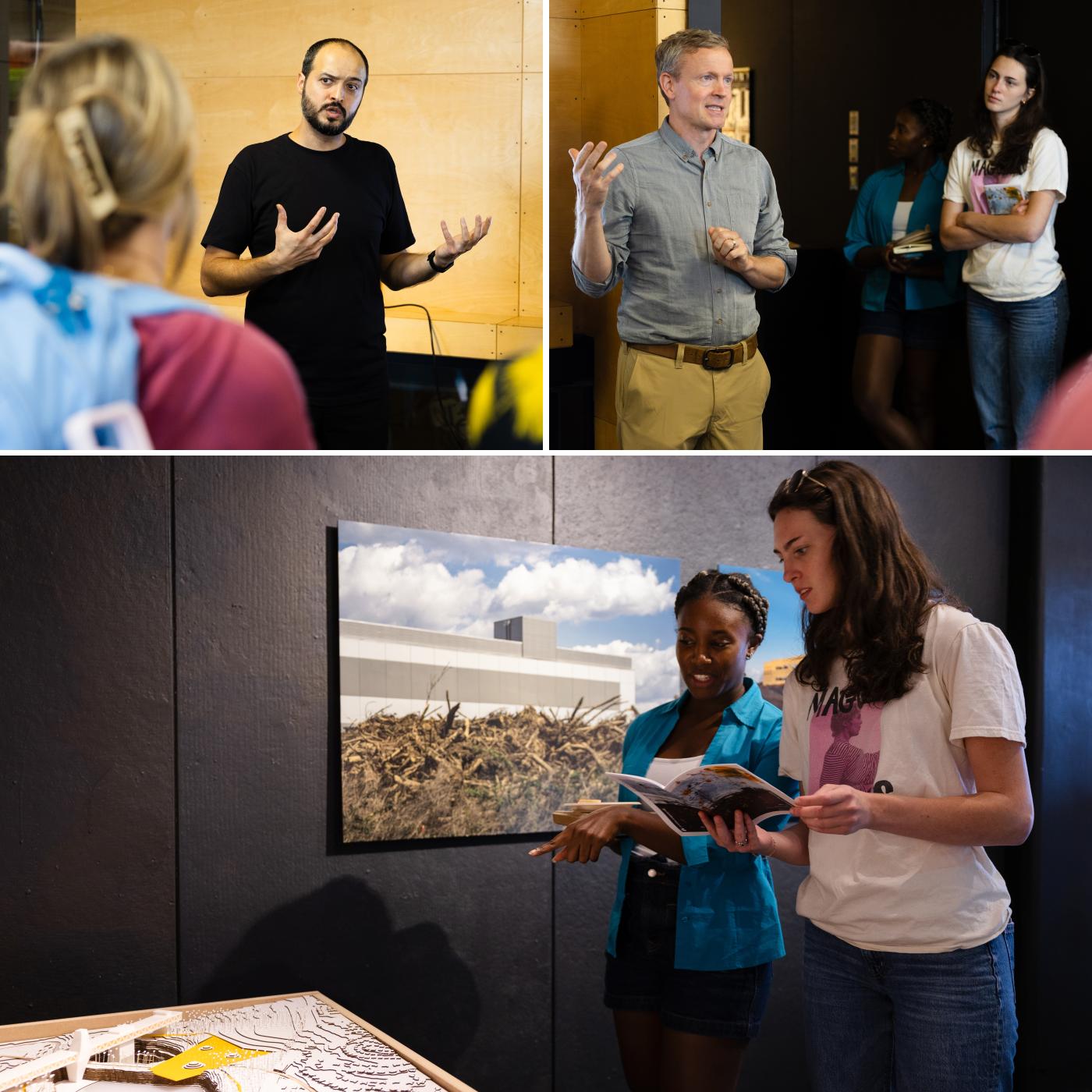
On display at the UVA School of Architecture's Elmaleh Gallery, the exhibition In the Shadow of the Cloud: Reimagining the Technical Landscapes of Northern Virginia unveils how the modern spatial history of Northern Virginia is intrinsically tangled with the development and growth of digital technologies and their networks. This body of design research, curated and conceived of by Assistant Professor of Architecture Ali Fard, recounts the histories and trajectories that have contributed to the region's emergence as the world's largest data market over the past five decades. Fard, who directs the Media, Infrastructure, Speculative Territories Laboratory (MIST_lab) at UVA, explores emerging media and infrastructural systems as both the sites and means of speculative design research on urbanism.
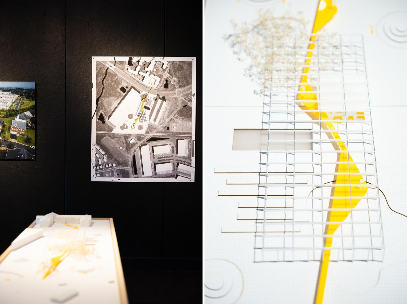
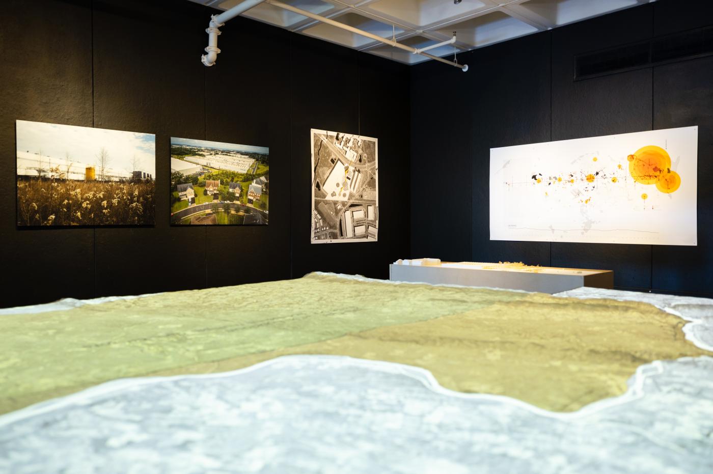
The multimedia exhibition features a series of interventions by MIST_lab including a 1:20,000 scale model of Northern Virginia's topography that interacts with projected maps, drawings, videos, and images to produce a multifaceted reading of the infrastructural palimpsest of NOVA. Other interventions include models that project what the future of Northern Virginia sites may look like by examining three spatial typologies: the quarry, the data center, and the highway interchange.
In dialogue with the architectural and urban representations of MIST_lab, the exhibition includes a selection of photographic works by Stephen Voss, a Washington, D.C.-based photographer who is well known for his portraits, most often of American politicians. While the ten large-format photographs in this exhibition are a departure from his typical portraits, the works instead provocatively document the realities of the built environment. They strikingly portray the overt physicality of the so-called ephemeral "cloud" — a landscape shaped by data centers which he describes as "symbols of our limitless demand for digital connection and the steep, often unseen price it exacts."
It is estimated that around 70% of all internet traffic at some point passes through the data center and exchange hubs that dot the region of NOVA. — MIST lab
Fard's research, nearly five years in the making, examines this quickly changing landscape, home to the largest concentration of data centers in the world. In Loudoun County, there are more than 25 million square feet of data centers in operation, with another 4 million in development. As Fard explains, "This is the infrastructural landscape that underwrites the rapid expansion of artificial intelligence and bolsters the growth of smart cities."
Image
Why Northern Virginia?
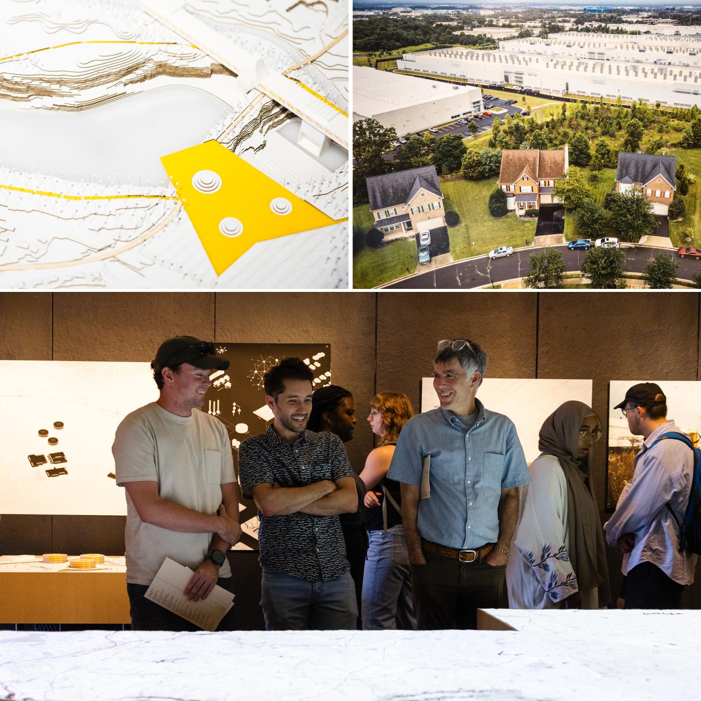
In a gallery talk held at the School of Architecture's Campbell Hall, Fard shared how this project began with a bike ride along the Washington and Old Dominion Trail many years ago. During his ride, Fard was struck by the how mundane the trail felt — and the jarring observations of the evolution of the trail over centuries as a central piece of infrastructure in Northern Virginia. Fard explained how he experienced, "the literal vibrations of the machinery, humming from the power substations," paired with observations of football field-sized buildings that were windowless and impervious. The 21st-century data center landscape along the trail was both unremarkable and made its presence felt.
From these observations, Fard began to investigate the history and evolution of the 45-mile trail, and its centrality to the continual development of the region's urban landscape and infrastructural spaces. In the Shadow of the Cloud not only maps and tells the story of how the NOVA landscape evolved to what it is today, it also speculates on the next fifty years. Fard, with student researchers at MIST_lab, examined three prominent spatial typologies that exist along the Washington and Old Dominion Trail, considering how they may evolve to address community needs and integration into the urban fabric that surrounds it.
Image
A Catalog of Typologies
In addition to the increasing energy demands of data centers, they also consume large amounts of water. Data center water usage in Northern Virginia has increased by almost two-thirds since 2019 and to address increasing project demand, new initiatives in Loudoun County are exploring the potential to retrofit quarries at the end of their life into water reservoirs.
We suspect that a large portion of this water would go toward quenching the thirst of data centers. — MIST lab
Through a speculative design proposal, MIST_lab posits reactivating the quarry, turned reservoir, by combining the functional needs of infrastructure with programmatic spaces that support a diversity of recreational and cultural uses.
The lab addresses the typology of the data center by considering its typical short lifespan of about twenty years. After that, they explain, the cost of maintenance and refurbishment may outweigh that of constructing new data centers. Their intervention imagines the adaptive reuse of data centers that focus on the architectural logics of the buildings — reusing the centers' facades, upper levels, and structural skeletons for recreational and cultural programming, high density housing, and social amenities — aiming to reconnect a disjointed urban fabric.
The final spatial typology examined is the highway interchange. The standardized cloverleaf structure of typical interchanges are efficient in directing traffic, but leave behind large tracts of underutilized spaces.
There are currently more than 40 cloverleaf interchanges in our [NOVA] study area. Around 44% of the spatial footprint of these interchanges remains underutilized. — MIST lab
By integrating a new type of data center into this unused space of the interchange, the lab proposes "creating space where it seemingly doesn't exist," and providing the needed infrastructural connectivity necessary for data centers within property that is not ideal for other uses. Their strategy aims to keep the "outward territorial march of data centers in check, while creating new potential sources of revenue for state transportation agencies."
Image
Dark Fiber
Fard connected with photographer Stephen Voss not only for this exhibition but as a project collaborator in researching and speculating on the NOVA data landscape. In the gallery talk, Voss explained that he has been photographing the hidden infrastructure of "the cloud" in Northern Virginia for about two years. He shared, "Data centers are being built next to baseball fields, behind schools and homes, and alongside historic cemeteries. I was curious about what these place actually look like, and what it felt like to be around them."
For most of the world, they are an abstraction, but data centers are a crucial part of our modern world, and our demand for computational power comes with a cost that is unequally distributed. — S. Voss
Through his photography, Voss has come to better understand the "real, physical strains" that data centers as resource-hungry building place on the urban landscape of Northern Virginia and the communities that live there.
Image
Through the exhibition and accompanying gallery talk, attendees were invited to consider the intricate ties and continued dependencies that our daily lives have formed with technical landscapes. MIST_lab's design provocations and Voss' photographic depictions together reveal the tangible and physical moments where the cloud meets the ground.
Exhibition Credits
Curation
Ali Fard, in collaboration with Stephen Voss
Student researchers
Leo Wehner, Sarah O'Donnell, Dorothy Philip, Treston Yetso, and Ari Bell
Fabrication Consultation
Trevor Kemp and Melissa Goldman
Exhibition Coordination
Kyle Sturgeon
Supported by the Office of the Dean at the UVA School of Architecture and the UVA Environmental Institute