
Landscape Architecture Studios and Student Projects Recognized Internationally by WLA
|
Image

|
We extend our congratulations to current students and recent graduates of the School of Architecture's Master of Landscape Architecture program, and faculty leading advanced research studios, for being recognized by World Landscape Architect (WLA). In the recently announced 2025 WLA Student Awards, two student projects and two studios received honors as finalists and winners, selected by a world-class jury that acknowledged the best student work in design, analysis and planning. This year's awards received 161 entries from over 30 countries worldwide with 22 awards selected across 5 categories.
AWARD OF EXCELLENCE—
LEENA CHO + MATTHEW JULL, ARCTIC DESIGN GROUP
UNIVERSITY STUDIO (TEACHING) CATEGORY—
PERMAFROST FUTURES: CITY BUILT ON THAWING GROUND
Advanced Research Studio
Award submission recognizes student projects by Ari Bell (MLA '25), Joyce Fong (MLA '25), Shuai Yuan (MLA ’25), Alex Daley (MArch/MLA ’25), Margaret Saunders (MArch ’25), Katherine Shi (BSArch ’25) and Julia Shehadi (MArch ’25)
Semester—Fall 2024
Studio Description:
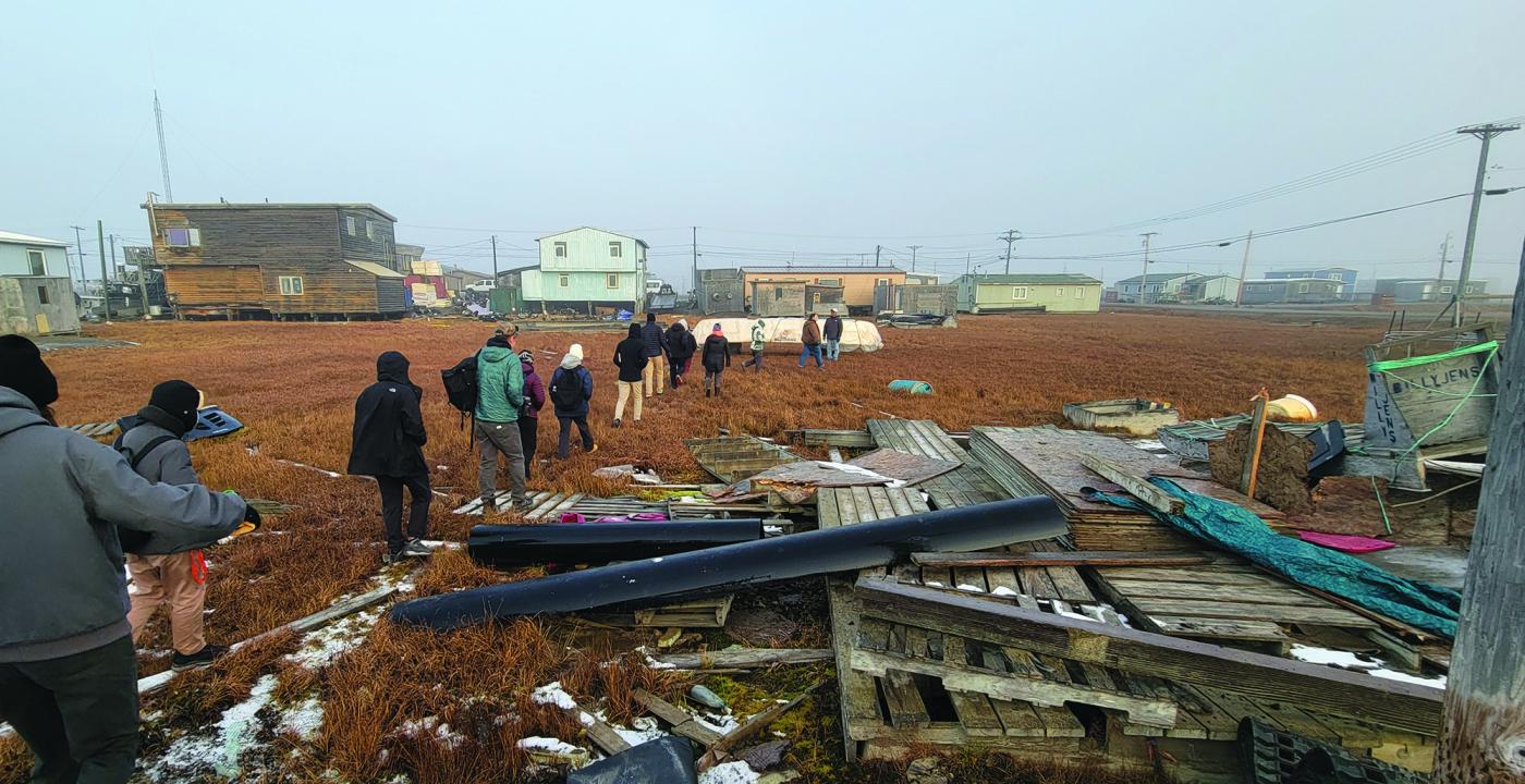
The Arctic is warming up to four times faster than the global average, accelerating permafrost thaw and destabilizing infrastructure, ecosystems, and Indigenous livelihoods. Utqiaġvik, Alaska — the northernmost U.S. community and largest Iñupiat settlement — stands at the forefront of these changes. Permafrost degradation disrupts foundations, utilities, and transportation systems; accelerates coastal erosion; alters ecosystems; heightens food insecurity; releases contaminants; and increases health risks. Smaller Alaskan communities such as Utqiaġvik have limited capacity to monitor and mitigate these impacts. This graduate and undergraduate design research studio, Permafrost Futures, investigates how landscape and urban design can respond to these challenges. Working in close collaboration with local partners, students engage in fieldwork and science — and data-based spatial analysis — to develop design and landscape management strategies directly addressing community needs.
Image
Image
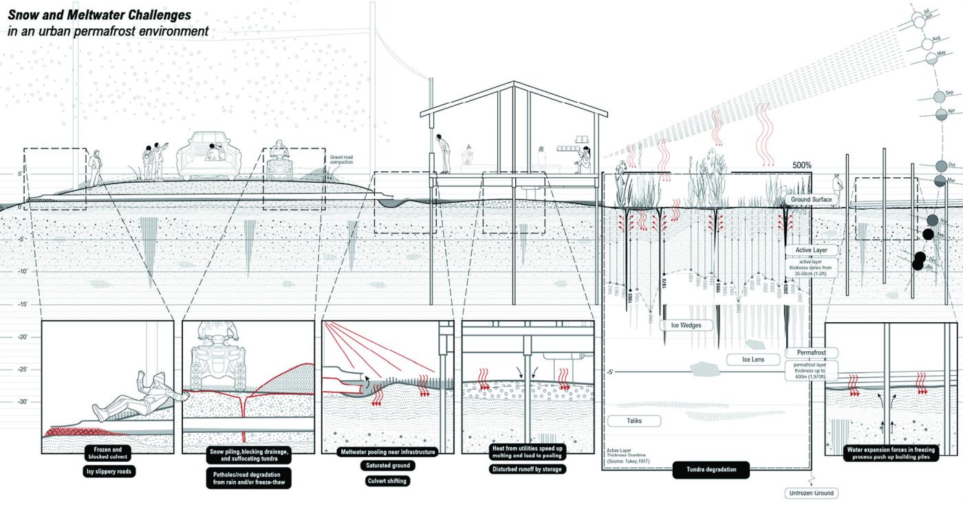
The studio is part of a five-year (2021-26) federally funded, interdisciplinary research effort supported by the U.S. National Science Foundation. Led by Associate Professors Leena Cho and Matthew Jull who have more than a decade of sustained engagement in Utqiaġvik, the broader project brings together faculty, students (undergraduate, graduate, and Ph.D.), and postdoctoral researchers across environmental sciences, engineering, social science, data science, landscape architecture, and architecture. The research examines the interaction between community infrastructure and the surrounding landscape, and the effects of climate change on future infrastructure and building design.
"The studio functions as a living laboratory rooted in reciprocity, where design research directly supports community priorities while contributing to the profession's capacity to address climate adaptation in extreme environments."
—Excerpt from Studio Brief
HONORABLE MENTION —
CHEUK HEI (AGNES) TO, MLA '25
HETVEE PANCHAL, MLA '26
YUK CHING (SARAH) CHEANG, MLA ‘25
CONCEPT CATEGORY— LARGE DESIGN
CHOREOGRAPHY OF AN ISLAND DISAPPEARANCE
Landscape Architecture Foundation Studio IV, Prototyping the Bay: Landscape as Medium
Studio Instructors—Bradley Cantrell
and Leena Cho
Semester—Spring 2025
Project Description:
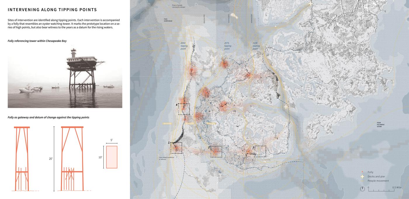
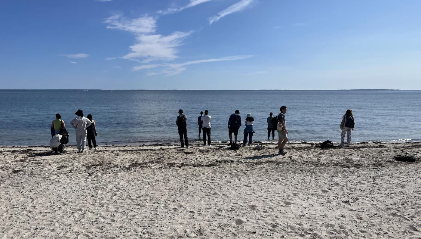
Located in the middle Chesapeake Bay, Cedar Island Wildlife Management Area (Cedar Island WMA) marks the intersection of Tangier Sound and Pocomoke Sound, also delineates state boundaries between Virginia and Maryland. Yet, one barely registers its presence — it is currently uninhabited and only accessible by boat. Its contradiction of being invisible yet somewhat important makes it valuable for experimenting new approach to disappearing islands. However, these qualities also suggest its vulnerability to sea level rise, being the first to submerge in the Sounds. The Bay’s flat terrain is susceptible to rising waters and large-scale subsidence, where water has risen about 1 foot in the past century, and projections estimate another 1.3 to 5.2 feet of rise over the next hundred years. This project asks: Is the Bay ready for this?
Image
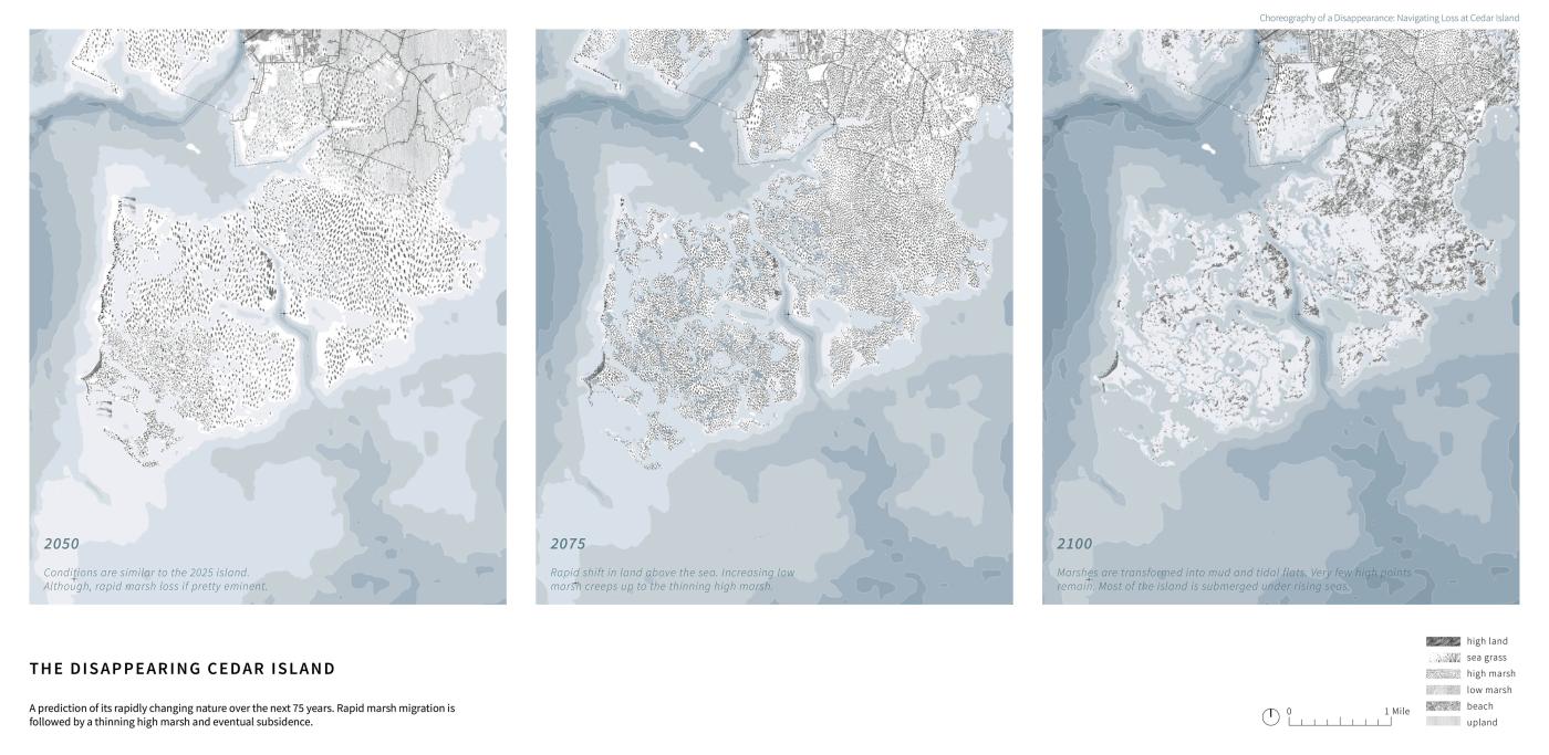
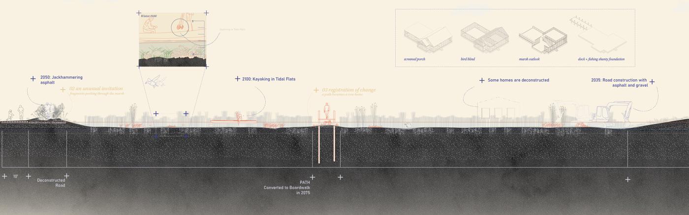
Choreography of a Disappearance: Navigating Loss at Cedar Island explores edges as spaces between the known and unknown, exhibiting hybrid conditions of ‘almostness’. The more tangible edges are the predicted marshland migration in the next 75 years. Cedar Island is expected for eminent marsh loss, with low marsh expanding and high marsh thinning, eventually transforming into mudflats and tidal flats punctuated by few high points. The island’s retreating outlines in 2050, 2075, and 2100 serve as key ‘tipping points’.
Recording existing forms and local operations within the bay, the project team catalogued found and imagined ‘almost’ conditions to represent actions and reactions between human and islands. Through time, they reshape spaces into almost familiar, almost unfamiliar conditions, merging known operations with unknown landscapes, drawing people closer to seemingly unfamiliar coastal changes of rising waters. Prototype sites are anchored with a 20-feet folly, acting as a gateway to signal afar and record datum changes locally.
"Our project is positioned to shed light on these overlooked islands. As an experimental ground, the Cedar Island prototypes demonstrate ways of accepting and remembering loss, adapting to changed habitats and spreading tangible memories.”
—Excerpt from Project Narrative
Image
Uninhabited islands and exposed edges like Cedar Island face yet the most impact from flooding, erosion and subsidence. These edges are often reshaped into technological solutions including living shorelines, seawalls or simply as sacrificial land protecting inland cities like Cedar Island to Crisfield. While prioritizing inland populations is reasonable given limited resources and capacity of local agencies, these islands disappear without traces and acknowledgement, despite their coastal protection for human and habitat provision for wildlife of the Bay. This project imagines a life beyond submersion and activates people's agency to hold on to lands threatened with loss.
FINALIST —
ALEX DALEY, MLA '25 / M.ARCH '25
ALEX FRY, MLA '25
ALEXANDER HEALD, MLA '26
RUTH SHATKAY, MLA ‘26
CONCEPT CATEGORY— LARGE DESIGN
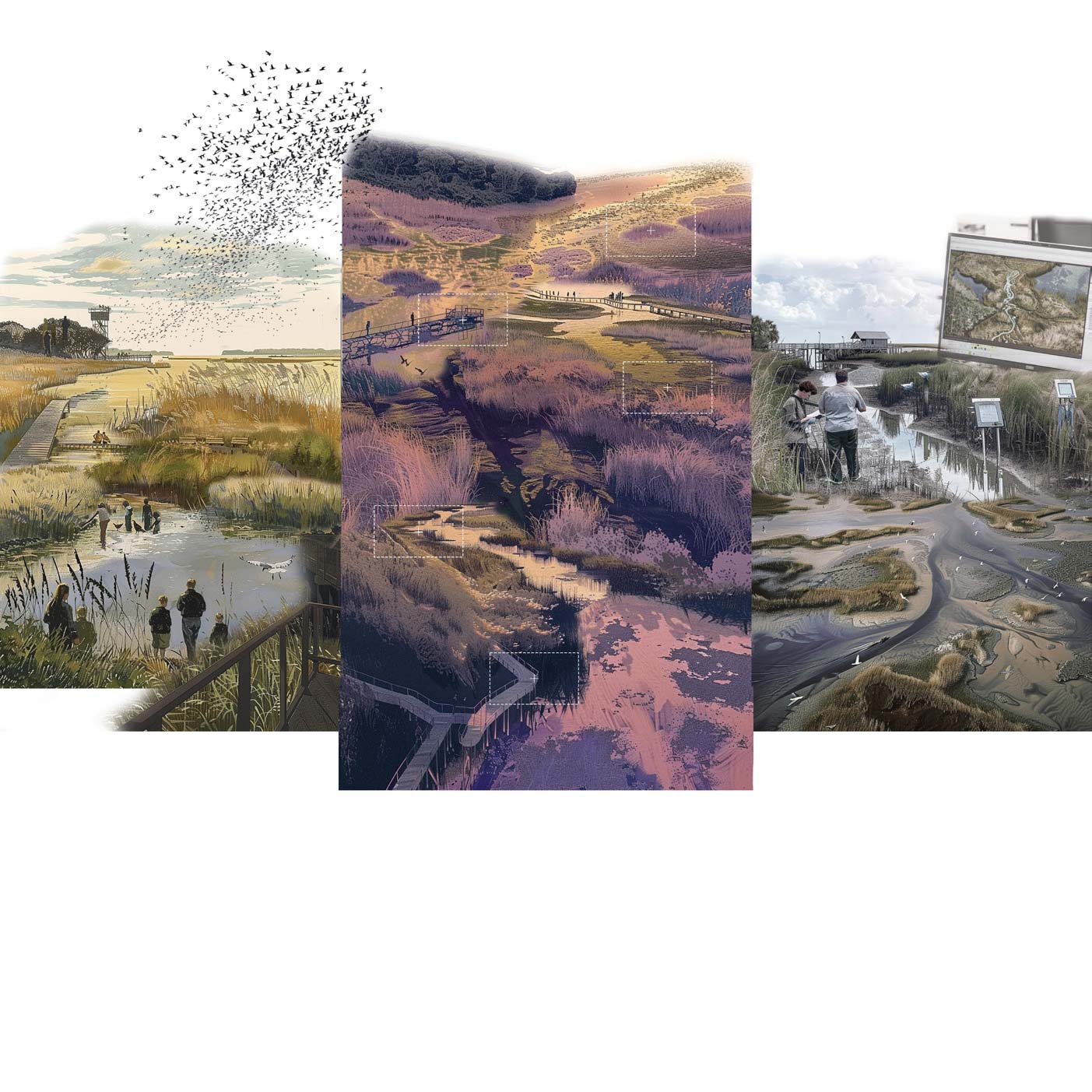
MARSH RHYTHMS
Landscape Architecture Foundation Studio IV, Prototyping the Bay: Landscape as Medium
Studio Instructors—Bradley Cantrell
and Leena Cho
Semester—Spring 2025
Project Description:
Marsh Rhythms proposes an approach to climate adaptation on Maryland and Virginia's Eastern Shore that responds to the wonder that is present there, today and into the future. Recognizing that this region's character emerges from human and cultural connections to the water and marshes of the Chesapeake Bay, the proposal seeks to build upon these relationships and amplify the beauty and mystery so intrinsic to the Bay. This project centers around Crisfield, Maryland, one of the largest Bay-facing towns on the Eastern Shore and a place whose culture has long been shaped by negotiations with water.
Historically, Crisfield's economy was driven by the seafood industry; the town was built on oyster shells discarded from seafood processing. Although the Bay has shaped the town, today it is also a point of increasing worry. To address worsening tidal flooding, the National Oceanic and Atmospheric Administration (NOAA) together with local partners have proposed a plan of bulkheads and berms around the city. Expected to protect Crisfield from five feet of flooding, the plan risks severing the city from the surrounding landscape.
Image

Image
A foil to such protective measures, Marsh Rhythms is guided by people's longstanding relationships with the region's marshes, inviting the future, more watery landscape to continue to enrich the spirit of Crisfield.
"Through the design of an inhabitable marsh, our project aims to bring forward the wonder that will continue to be here, experienced through the majesty of this flat, expansive place, where the horizon is thin, the sky has a strong presence, and there is a rich complexity in its monotony.”
—Excerpt from Project Narrative
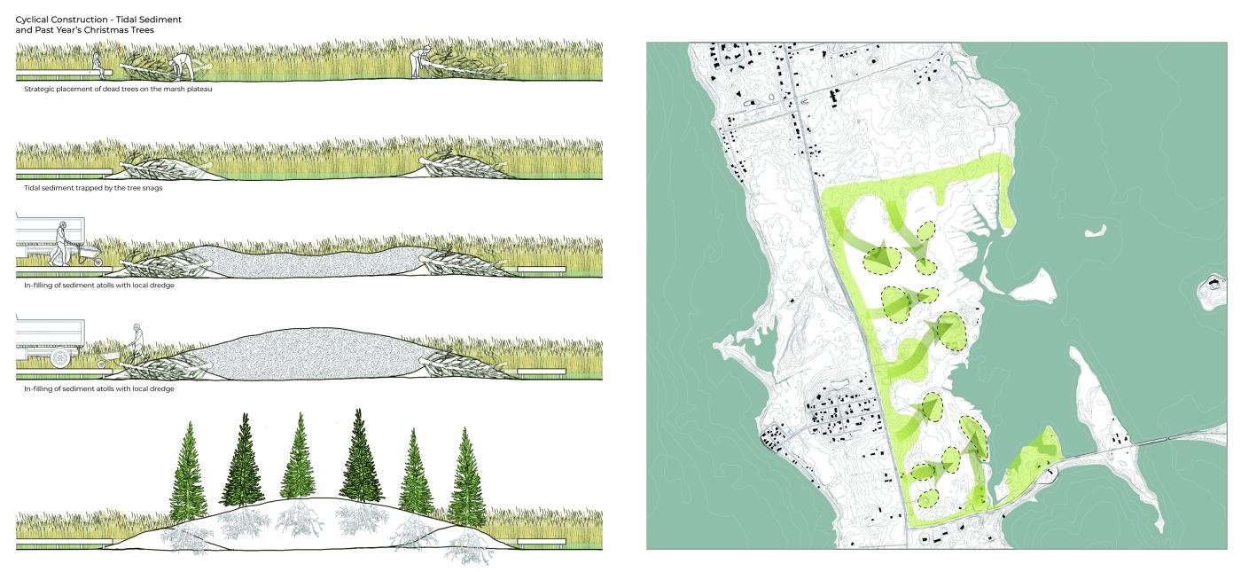
Within the bounds of the NOAA adaptation plan, areas behind houses and extant ditches become marshy zones for managing trapped water while providing shared areas for gathering and being. Outside the adaptation plan, where the marsh is currently prominent and expanding, the team proposes a network of raised paths. Several existing roads become elevated, enabling longer-term access to homes. Stemming from these roads, berms and path tendrils branch into the marsh, inviting people to linger in the expansiveness of this landscape. As houses in this area are abandoned, some paths will lead to converted structures: screened porches, enclosed gardens, and outlooks over the grasses. With time, old foundations can serve as the base of fishing shanties for watermen, who, within 75 years, will be able to launch their boats from here.
The proposed paths are composed primarily of crushed oyster shells, inspired by Crisfield's landforming traditions. In addition to recalling this unique and wondrous history, the paths will gain new life in the future, once they're submerged and form the foundation for new oyster reefs.
Through incisive moves that highlight the landscape's cultural and ecological character, the student team hopes that the marsh and water can be a beautiful place with refreshed relevance for the area's residents and visitors into the future. More broadly, they suggest an approach to climate adaptation where the spirit of the place colors infrastructural plans and its wondrous qualities are centered.
FINALIST—
MICHAEL LUEGERING
UNIVERSITY STUDIO (TEACHING) CATEGORY—
CIVIC INFRASTRUCTURE AND ADAPTATION
Advanced Research Studio
Award submission recognizes student projects by Mariya Anwar (MUD '23), Frances Carraway (BSArch '24), Twisha Gandhi (MUD '23), Vishal Jayan (MUD '23), Zaoqing Liu (MUD '23), Shunan Na (MLA '24), Christopher Parschalk (MUD '23), Emma Potter (MLA '24), John Ruff (BSArch '24), Xinyi Shao (MLA '24), Zoque Wahid (MUD '23), John Ward (MUD '23), Pandora Zhang (BSArch '24)
Semester—Fall 2023
Studio Description:
Civic Infrastructure and Adaptation is a yearly studio that focuses on scenario-based preemptive adaptation, nature-based infrastructure exploration and community engagement to design for an array of outcomes in small coastal communities in New England. At the heart of the studio is a question of how we can envision the preemptive migration of communities aided by, through and with natural systems? Further, how might we design, optimistically and strategically, for an uncertain future that embraces planted infrastructure as a colloquial condition which is inextricably linked to the ethos and daily lives of local residents?
Image
The studio starts by considering the history of federal infrastructure and its impact on local culture. Federal policies and programs governing coastal management have been, primarily, disaster driven. This reliance on civil works to avoid disasters has historically created wide swings between perceived stability and emergency. Civic Infrastructure and Adaptation considers both the physical and cultural project of preemptive action with a focus on plants and details. The studio asks: how do we position a contemporary take on the process of migration and preemptive adaptation that relies on planted strategies and timelines? how do the creation of novel, adapted ecological systems comingle with long-established perceptions of coastal environments?
"How do the creation of novel, adapted ecological systems co-mingle with long-established perceptions of coastal environments?”
—Excerpt from Studio Brief
Image
The studio has had the privilege of admission into and participation with the Envision Resilience Challenge program. This resulted in several immense programmatic opportunities for students. Financial support for travel costs to project sites and studio materials for design studies enabled the studio to maximize its focus on iterative model studies at multiple scales without burdening student finances. Advancement and improvement in form making, iterative studies, and the ability to use renewable materials freely to explore ideas resulted in marked improvement in spatial concepts and a growth in understanding of landscape process.
Also as a part of the Envision Resilience Program, the studio was able to build off of the community engagement groundwork , world renowned design lectures and critiques as well as public dissemination back into the community via public exhibitions – providing students with an exceptional experience. The exposure of the students' work within these coastal communities has helped not only offer visions for future opportunities around which they might build conversations and consensus, but it has also exposed many residents and officials, alike, to the role of landscape architecture in the planning and design of adaptation in coastal landscapes.
2025 WLA STUDENT AWARDS JURY—
Panita Karamanea
Assistant Professor of Architectural Space and Landscape Design,
School of Architecture NTUAthens, March NTUA, MLA & PhD UTP ETSABarcelona UPC
Wang Ling
Associate Professor, Doctoral Supervisor, and Chair of the Department of Landscape Architecture, School of Design, Shanghai Jiao Tong University
David D. Pearson
Lecturer, Landscape Architecture Program in School of Architecture, Clemson University
William Shivers
Assistant Professor of Landscape Architecture, University of Hong Kong